


R1T-A517-25-Bosses

Jack-94
User
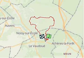

Length
12.7 km

Max alt
119 m

Uphill gradient
247 m
Km-Effort
16 km

Min alt
67 m

Downhill gradient
247 m
Boucle
Yes
Creation date :
2024-05-12 06:51:37.089
Updated on :
2024-05-14 10:22:33.091
6h32
Difficulty : Difficult

FREE GPS app for hiking
 SityTrail
IGN / Geographical institutes
SityTrail Plus
The world is yours!
About
Trail Walking of 12.7 km to be discovered at Ile-de-France, Seine-et-Marne, Le Vaudoué. This trail is proposed by Jack-94.
Positioning
Country:
France
Region :
Ile-de-France
Department/Province :
Seine-et-Marne
Municipality :
Le Vaudoué
Location:
Unknown
Start:(Dec)
Start:(UTM)
465517 ; 5356367 (31U) N.
Comments